
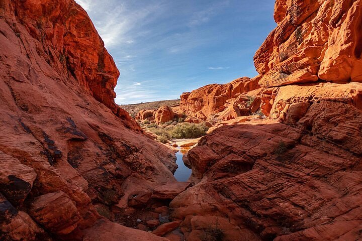
What Red Rock Canyon is
Red Rock Canyon National Conservation Area is 195,000 acres of Mojave Desert managed by the Bureau of Land Management, beginning where the western suburbs of Summerlin stop. Its signature is the Keystone Thrust, a fault that pushed grey limestone over younger red Aztec sandstone and left a wall of striped cliffs rising up to 3,000 feet above the valley floor. The Calico Hills, the bright orange-and-cream domes nearest the entrance, are what most people picture when they say Red Rock.
From the centre Strip it is 17 miles west along Charleston Boulevard, and on a normal day you are at the entrance station in 30 to 35 minutes. That proximity is the whole point: you can sit at a table at midnight and be scrambling over sandstone at 8am. A visitor centre with exhibits and a desert tortoise habitat sits just inside the gate, and the 13-mile one-way Scenic Drive loops through the best of it with a dozen pull-offs and trailheads. Alongside Hoover Dam it is the essential quick escape from Las Vegas.
Fees and the timed-entry reservation
Entry is charged per vehicle, and as of 2026 the day pass has generally been in the $15 to $20 range for a car, with lower rates for motorcycles and bicycles and America the Beautiful national parks passes accepted; check the official Red Rock Canyon site for current fees. The pass covers the Scenic Drive and all trails. Pay by card at the entrance station or in advance online.
The important wrinkle is the timed-entry reservation. During the busy season — broadly October through May — vehicles entering the Scenic Drive between early morning and late afternoon need a reservation for a specific hour, booked on Recreation.gov for a small fee on top of the entry pass. Reservations open weeks ahead and popular weekend morning slots go quickly. Outside those hours and in summer, no reservation is needed. Arriving without one in peak season means being turned around at the gate, which happens to Strip visitors every weekend. Check the current reservation window on the official site before you go, and print or screenshot the confirmation, because phone signal at the entrance is patchy.
The Scenic Drive
The 13-mile Scenic Drive is one-way, paved, and takes about 45 minutes with no stops or two to three hours if you get out at the good ones. The road opens at dawn and closes in the evening with the gate time varying by season. The first stop, Calico I and Calico II, puts you right under the orange domes and is where most people take their photos. Sandstone Quarry, a mile on, is the trailhead for Calico Tanks and the Turtlehead Peak climb. The High Point Overlook at 4,771 feet gives the sweep back across the valley to the Strip.
Beyond that the road drops past Ice Box Canyon, Pine Creek Canyon and the Willow Springs picnic area, where a short walk reaches Indigenous rock art and agave roasting pits. There is no water, food or fuel on the loop and no way to turn back once you are on it, so top up the tank and fill bottles before the gate. Cyclists share the road and the climbs are steep; give them room on the blind bends. Pull-offs fill by mid-morning on cool-season weekends, another argument for the first reservation slot of the day.
The best short hikes
- Calico Tanks (2.5 miles round trip, moderate). The classic. A sandstone wash climbs to a seasonal pool and a ledge with a view of the whole valley and the Strip. Some scrambling; two hours.
- Calico Hills (variable, easy to moderate). Wander the domes from Calico I or II with no set route — great for kids who want to climb.
- Ice Box Canyon (2.6 miles, moderate). A shaded slot with seasonal waterfalls; the coolest walk on hot days. Rocky in the upper section.
- Lost Creek – Children's Discovery Trail (0.75 miles, easy). A loop to a seasonal waterfall and rock art, ideal for young families.
- Pine Creek Canyon (3 miles, easy to moderate). Passes the foundations of a 1920s homestead into a ponderosa-lined canyon.
- Turtlehead Peak (5 miles, strenuous, 2,000 feet of gain). The summit view is the best in the area; start at dawn and only in cool weather.
Trails are unmarked in places and the sandstone all looks alike; download an offline map. See our kids guide for the easiest options with children.
When to go and the heat
Red Rock is at its best from October to April, when daytime highs sit between 55°F and 80°F and the light on the sandstone is warm and low. Spring brings wildflowers after a wet winter. Summer is a different proposition: the loop sits in full sun, temperatures regularly pass 105°F by noon and rescues of underprepared hikers are routine. If you visit in June, July or August, be through the gate at opening, walk before 9am, and treat the drive as a car-based sightseeing loop after that. Ice Box Canyon is the only trail with meaningful shade.
Go early in any season. First light hits the Calico Hills from the east and makes them glow; by afternoon they are flat and washed out. Sunset works the other way — the cliffs to the west go copper as the sun drops behind them, and the Red Rock Overlook on State Route 159, outside the fee area, is a free and popular place to watch it. Winter can bring snow on the high peaks and the occasional closure of the loop road for ice; that is also when the place is emptiest and most beautiful.
Getting there without a car
There is no public transport to Red Rock. Rideshare from the Strip is feasible on the way out — roughly 30 minutes and a moderate fare — but getting a ride back from inside the loop is unreliable because drivers rarely wait in the area and signal is weak; if you do it, arrange the return at the visitor centre or the Red Rock Casino in Summerlin, which sits five miles east on Charleston. A one-day rental is often cheaper than two rideshare trips and gives you the whole loop; see our transportation hub.
Tours are plentiful and mostly good value. Half-day guided hiking tours from the Strip cover the reservation, the pass and a knowledgeable guide; e-bike and road-bike tours ride the Scenic Drive; scooter-car and open-air jeep tours suit people who want the views without walking. Some sunset tours combine Red Rock with a stop at Seven Magic Mountains, which makes an efficient loop. Many run under $100 and a few under $50 — our budget tours guide covers those.
Insider tips and mistakes to avoid
Book the earliest reservation slot you can and be at the gate 15 minutes before it; you cannot enter early, but the queue forms. Bring a litre of water per person per two hours and more in summer, plus a hat — the visitor centre sells water but nothing on the loop does. Wear grippy shoes; the sandstone is fine when dry and treacherous when wet, and the Calico scrambles need hands. Stay off the rock for 24 hours after rain — wet sandstone crumbles and climbing it is banned. Do not stack rocks, carve names or feed the burros you might see on 159.
The most common mistakes are turning up at 11am on a February Saturday without a reservation, starting Turtlehead Peak at noon in May, and driving the loop without stopping. The second most common is going home too early: Bonnie Springs is gone, but Spring Mountain Ranch State Park, five miles further along 159, is a green oasis with a historic ranch house, and the drive on to the tiny village of Blue Diamond makes a satisfying loop back via Blue Diamond Road. Compare it with Valley of Fire if you want a bigger, wilder version an hour further out.


